| at: |
Homochitto National Forest |
Data from USFS GIS
 show on map
 animate
Trail users:


Elevation Profile
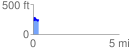
 0.311484 mi
 95.08 ft
 81.29 ft
 13.79 ft
 5.78 %
GPX Downloads: Track Route
![]()
| at: |
Homochitto National Forest |
show on map
animate
0.311484 mi
95.08 ft
81.29 ft
13.79 ft
5.78 %