| at: |
Homochitto National Forest |
Data from USFS GIS
 show on map
 animate
Trail users:


Elevation Profile
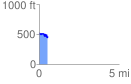
 0.546916 mi
 73.03 ft
 118.05 ft
 -45.02 ft
 4.09 %
GPX Downloads: Track Route
![]()
| at: |
Homochitto National Forest |
show on map
animate
0.546916 mi
73.03 ft
118.05 ft
-45.02 ft
4.09 %