| at: |
Homochitto National Forest |
Data from USFS GIS
 show on map
 animate
Trail users:


Elevation Profile
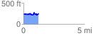
 1.254832 mi
 231.76 ft
 236.20 ft
 -4.44 ft
 3.56 %
GPX Downloads: Track Route
![]()
| at: |
Homochitto National Forest |
show on map
animate
1.254832 mi
231.76 ft
236.20 ft
-4.44 ft
3.56 %