| at: |
Homochitto National Forest |
Data from USFS GIS
 show on map
 animate
Trail users:


Elevation Profile
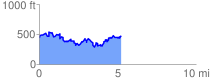
 5.319485 mi
 1293.09 ft
 1273.35 ft
 19.74 ft
 4.60 %
GPX Downloads: Track Route
![]()
| at: |
Homochitto National Forest |
show on map
animate
5.319485 mi
1293.09 ft
1273.35 ft
19.74 ft
4.60 %