| at: |
Homochitto National Forest |
Data from USFS GIS
 show on map
 animate
Trail users:


Elevation Profile
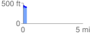
 0.306322 mi
 71.64 ft
 68.49 ft
 3.15 ft
 4.43 %
GPX Downloads: Track Route
![]()
| at: |
Homochitto National Forest |
show on map
animate
0.306322 mi
71.64 ft
68.49 ft
3.15 ft
4.43 %