| at: |
Homochitto National Forest |
Data from USFS GIS
 show on map
 animate
Trail users:


Elevation Profile
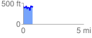
 0.795941 mi
 220.71 ft
 193.79 ft
 26.92 ft
 5.25 %
GPX Downloads: Track Route
![]()
| at: |
Homochitto National Forest |
show on map
animate
0.795941 mi
220.71 ft
193.79 ft
26.92 ft
5.25 %