|
| at: |
Homochitto National Forest |
Data from USFS GIS
 show on map
 animate
Trail users:


Elevation Profile
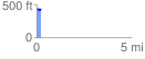
 0.237791 mi
 32.54 ft
 42.66 ft
 -10.12 ft
 3.40 %
GPX Downloads: Track Route
![]()
|
| at: |
Homochitto National Forest |
show on map
animate
0.237791 mi
32.54 ft
42.66 ft
-10.12 ft
3.40 %