| at: |
Homochitto National Forest |
Data from USFS GIS
 show on map
 animate
Trail users:


Elevation Profile
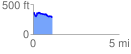
 1.121412 mi
 135.91 ft
 200.48 ft
 -64.57 ft
 3.39 %
GPX Downloads: Track Route
![]()
| at: |
Homochitto National Forest |
show on map
animate
1.121412 mi
135.91 ft
200.48 ft
-64.57 ft
3.39 %