| at: |
Homochitto National Forest |
Data from USFS GIS
 show on map
 animate
Trail users:


Elevation Profile
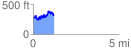
 1.230883 mi
 363.40 ft
 315.11 ft
 48.29 ft
 5.59 %
GPX Downloads: Track Route
![]()
| at: |
Homochitto National Forest |
show on map
animate
1.230883 mi
363.40 ft
315.11 ft
48.29 ft
5.59 %