| at: |
Homochitto National Forest |
Data from USFS GIS
 show on map
 animate
Trail users:


Elevation Profile
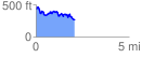
 2.096098 mi
 363.50 ft
 516.28 ft
 -152.78 ft
 4.66 %
GPX Downloads: Track Route
![]()
| at: |
Homochitto National Forest |
show on map
animate
2.096098 mi
363.50 ft
516.28 ft
-152.78 ft
4.66 %