| at: |
Homochitto National Forest |
Data from USFS GIS
 show on map
 animate
Trail users:


Elevation Profile
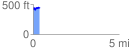
 0.393936 mi
 92.45 ft
 54.46 ft
 37.99 ft
 4.44 %
GPX Downloads: Track Route
![]()
| at: |
Homochitto National Forest |
show on map
animate
0.393936 mi
92.45 ft
54.46 ft
37.99 ft
4.44 %