|
| at: |
Homochitto National Forest |
Data from USFS GIS
 show on map
 animate
Trail users:


Elevation Profile
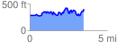
 3.508743 mi
 801.52 ft
 689.69 ft
 111.83 ft
 4.33 %
GPX Downloads: Track Route
![]()
|
| at: |
Homochitto National Forest |
show on map
animate
3.508743 mi
801.52 ft
689.69 ft
111.83 ft
4.33 %