| at: |
Homochitto National Forest |
Data from USFS GIS
 show on map
 animate
Trail users:


Elevation Profile
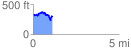
 1.121162 mi
 210.27 ft
 243.80 ft
 -33.53 ft
 4.12 %
GPX Downloads: Track Route
![]()
| at: |
Homochitto National Forest |
show on map
animate
1.121162 mi
210.27 ft
243.80 ft
-33.53 ft
4.12 %