| at: |
Homochitto National Forest |
Data from USFS GIS
 show on map
 animate
Trail users:


Elevation Profile
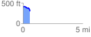
 0.593044 mi
 41.02 ft
 141.67 ft
 -100.65 ft
 4.52 %
GPX Downloads: Track Route
![]()
| at: |
Homochitto National Forest |
show on map
animate
0.593044 mi
41.02 ft
141.67 ft
-100.65 ft
4.52 %