| at: |
Homochitto National Forest |
Data from USFS GIS
 show on map
 animate
Trail users:


Elevation Profile
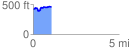
 1.061070 mi
 161.30 ft
 122.36 ft
 38.94 ft
 2.88 %
GPX Downloads: Track Route
![]()
| at: |
Homochitto National Forest |
show on map
animate
1.061070 mi
161.30 ft
122.36 ft
38.94 ft
2.88 %