|
| at: |
Homochitto National Forest |
Data from USFS GIS
 show on map
 animate
Trail users:


Elevation Profile
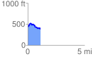
 1.116777 mi
 183.82 ft
 241.63 ft
 -57.82 ft
 4.10 %
GPX Downloads: Track Route
![]()
|
| at: |
Homochitto National Forest |
show on map
animate
1.116777 mi
183.82 ft
241.63 ft
-57.82 ft
4.10 %