|
| at: |
Homochitto National Forest |
Data from USFS GIS
 show on map
 animate
Trail users:


Elevation Profile
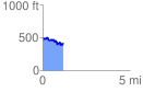
 1.189194 mi
 154.78 ft
 226.49 ft
 -71.71 ft
 3.61 %
GPX Downloads: Track Route
![]()
|
| at: |
Homochitto National Forest |
show on map
animate
1.189194 mi
154.78 ft
226.49 ft
-71.71 ft
3.61 %