|
| at: |
Homochitto National Forest |
Data from USFS GIS
 show on map
 animate
Trail users:


Elevation Profile
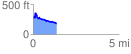
 1.375042 mi
 179.24 ft
 267.25 ft
 -88.01 ft
 3.68 %
GPX Downloads: Track Route
![]()
|
| at: |
Homochitto National Forest |
show on map
animate
1.375042 mi
179.24 ft
267.25 ft
-88.01 ft
3.68 %