| at: |
Homochitto National Forest |
Data from USFS GIS
 show on map
 animate
Trail users:


Elevation Profile
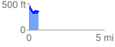
 0.649485 mi
 206.70 ft
 257.44 ft
 -50.73 ft
 7.51 %
GPX Downloads: Track Route
![]()
| at: |
Homochitto National Forest |
show on map
animate
0.649485 mi
206.70 ft
257.44 ft
-50.73 ft
7.51 %