| at: |
Homochitto National Forest |
Data from USFS GIS
 show on map
 animate
Trail users:


Elevation Profile
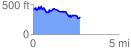
 2.750147 mi
 413.55 ft
 541.91 ft
 -128.36 ft
 3.73 %
GPX Downloads: Track Route
![]()
| at: |
Homochitto National Forest |
show on map
animate
2.750147 mi
413.55 ft
541.91 ft
-128.36 ft
3.73 %