| at: |
Homochitto National Forest |
Data from USFS GIS
 show on map
 animate
Trail users:


Elevation Profile
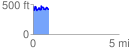
 0.920326 mi
 219.01 ft
 273.08 ft
 -54.07 ft
 5.62 %
GPX Downloads: Track Route
![]()
| at: |
Homochitto National Forest |
show on map
animate
0.920326 mi
219.01 ft
273.08 ft
-54.07 ft
5.62 %