|
| at: |
Homochitto National Forest |
Data from USFS GIS
 show on map
 animate
Trail users:


Elevation Profile
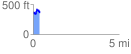
 0.386058 mi
 87.75 ft
 98.58 ft
 -10.83 ft
 4.84 %
GPX Downloads: Track Route
![]()
|
| at: |
Homochitto National Forest |
show on map
animate
0.386058 mi
87.75 ft
98.58 ft
-10.83 ft
4.84 %