| at: |
Homochitto National Forest |
Data from USFS GIS
 show on map
 animate
Trail users:


Elevation Profile
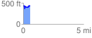
 0.593035 mi
 134.72 ft
 118.89 ft
 15.83 ft
 4.30 %
GPX Downloads: Track Route
![]()
| at: |
Homochitto National Forest |
show on map
animate
0.593035 mi
134.72 ft
118.89 ft
15.83 ft
4.30 %