| at: |
Homochitto National Forest |
Data from USFS GIS
 show on map
 animate
Trail users:


Elevation Profile
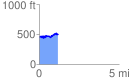
 1.160002 mi
 184.94 ft
 157.17 ft
 27.77 ft
 3.02 %
GPX Downloads: Track Route
![]()
| at: |
Homochitto National Forest |
show on map
animate
1.160002 mi
184.94 ft
157.17 ft
27.77 ft
3.02 %