| at: |
Homochitto National Forest |
Data from USFS GIS
 show on map
 animate
Trail users:


Elevation Profile
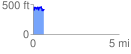
 0.630662 mi
 161.19 ft
 142.42 ft
 18.77 ft
 4.84 %
GPX Downloads: Track Route
![]()
| at: |
Homochitto National Forest |
show on map
animate
0.630662 mi
161.19 ft
142.42 ft
18.77 ft
4.84 %