| at: |
Homochitto National Forest |
Data from USFS GIS
 show on map
 animate
Trail users:


Elevation Profile
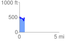
 0.676366 mi
 202.11 ft
 177.02 ft
 25.09 ft
 5.66 %
GPX Downloads: Track Route
![]()
| at: |
Homochitto National Forest |
show on map
animate
0.676366 mi
202.11 ft
177.02 ft
25.09 ft
5.66 %