|
| at: |
Homochitto National Forest |
Data from USFS GIS
 show on map
 animate
Trail users:


Elevation Profile
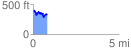
 0.837771 mi
 166.30 ft
 213.72 ft
 -47.42 ft
 4.83 %
GPX Downloads: Track Route
![]()
|
| at: |
Homochitto National Forest |
show on map
animate
0.837771 mi
166.30 ft
213.72 ft
-47.42 ft
4.83 %