|
| at: |
Homochitto National Forest |
Data from USFS GIS
 show on map
 animate
Trail users:


Elevation Profile
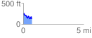
 0.703993 mi
 101.44 ft
 225.15 ft
 -123.71 ft
 6.06 %
GPX Downloads: Track Route
![]()
|
| at: |
Homochitto National Forest |
show on map
animate
0.703993 mi
101.44 ft
225.15 ft
-123.71 ft
6.06 %