| at: |
Homochitto National Forest |
Data from USFS GIS
 show on map
 animate
Trail users:


Elevation Profile
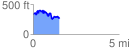
 1.552917 mi
 356.98 ft
 438.06 ft
 -81.08 ft
 5.34 %
GPX Downloads: Track Route
![]()
| at: |
Homochitto National Forest |
show on map
animate
1.552917 mi
356.98 ft
438.06 ft
-81.08 ft
5.34 %