| at: |
Homochitto National Forest |
Data from USFS GIS
 show on map
 animate
Trail users:


Elevation Profile
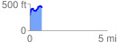
 0.775789 mi
 239.62 ft
 113.71 ft
 125.91 ft
 5.85 %
GPX Downloads: Track Route
![]()
| at: |
Homochitto National Forest |
show on map
animate
0.775789 mi
239.62 ft
113.71 ft
125.91 ft
5.85 %