|
| at: |
Homochitto National Forest |
Data from USFS GIS
 show on map
 animate
Trail users:


Elevation Profile
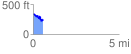
 0.565975 mi
 111.95 ft
 210.65 ft
 -98.70 ft
 7.05 %
GPX Downloads: Track Route
![]()
|
| at: |
Homochitto National Forest |
show on map
animate
0.565975 mi
111.95 ft
210.65 ft
-98.70 ft
7.05 %