| at: |
Homochitto National Forest |
Data from USFS GIS
 show on map
 animate
Trail users:


Elevation Profile
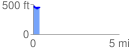
 0.363321 mi
 51.29 ft
 58.68 ft
 -7.39 ft
 3.06 %
GPX Downloads: Track Route
![]()
| at: |
Homochitto National Forest |
show on map
animate
0.363321 mi
51.29 ft
58.68 ft
-7.39 ft
3.06 %