| at: |
Homochitto National Forest |
Data from USFS GIS
 show on map
 animate
Trail users:


Elevation Profile
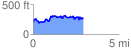
 2.918649 mi
 583.50 ft
 520.39 ft
 63.11 ft
 3.79 %
GPX Downloads: Track Route
![]()
| at: |
Homochitto National Forest |
show on map
animate
2.918649 mi
583.50 ft
520.39 ft
63.11 ft
3.79 %