| at: |
Homochitto National Forest |
Data from USFS GIS
 show on map
 animate
Trail users:


Elevation Profile
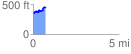
 0.742456 mi
 173.31 ft
 69.59 ft
 103.72 ft
 4.42 %
GPX Downloads: Track Route
![]()
| at: |
Homochitto National Forest |
show on map
animate
0.742456 mi
173.31 ft
69.59 ft
103.72 ft
4.42 %