|
| at: |
Homochitto National Forest |
Data from USFS GIS
 show on map
 animate
Trail users:


Elevation Profile
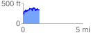
 1.350093 mi
 313.00 ft
 254.03 ft
 58.97 ft
 4.39 %
GPX Downloads: Track Route
![]()
|
| at: |
Homochitto National Forest |
show on map
animate
1.350093 mi
313.00 ft
254.03 ft
58.97 ft
4.39 %