|
| at: |
Homochitto National Forest |
Data from USFS GIS
 show on map
 animate
Trail users:


Elevation Profile
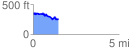
 1.477437 mi
 212.40 ft
 306.70 ft
 -94.30 ft
 3.93 %
GPX Downloads: Track Route
![]()
|
| at: |
Homochitto National Forest |
show on map
animate
1.477437 mi
212.40 ft
306.70 ft
-94.30 ft
3.93 %