| at: |
Homochitto National Forest |
Data from USFS GIS
 show on map
 animate
Trail users:


Elevation Profile
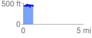
 0.848352 mi
 184.76 ft
 198.30 ft
 -13.54 ft
 4.43 %
GPX Downloads: Track Route
![]()
| at: |
Homochitto National Forest |
show on map
animate
0.848352 mi
184.76 ft
198.30 ft
-13.54 ft
4.43 %