|
| at: |
Homochitto National Forest |
Data from USFS GIS
 show on map
 animate
Trail users:


Elevation Profile
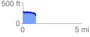
 1.110119 mi
 155.87 ft
 253.39 ft
 -97.52 ft
 4.32 %
GPX Downloads: Track Route
![]()
|
| at: |
Homochitto National Forest |
show on map
animate
1.110119 mi
155.87 ft
253.39 ft
-97.52 ft
4.32 %