|
| at: |
Homochitto National Forest |
Data from USFS GIS
 show on map
 animate
Trail users:


Elevation Profile
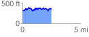
 2.507149 mi
 529.35 ft
 518.66 ft
 10.69 ft
 4.00 %
GPX Downloads: Track Route
![]()
|
| at: |
Homochitto National Forest |
show on map
animate
2.507149 mi
529.35 ft
518.66 ft
10.69 ft
4.00 %