| at: |
Homochitto National Forest |
Data from USFS GIS
 show on map
 animate
Trail users:


Elevation Profile
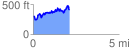
 2.150087 mi
 581.65 ft
 476.63 ft
 105.02 ft
 5.12 %
GPX Downloads: Track Route
![]()
| at: |
Homochitto National Forest |
show on map
animate
2.150087 mi
581.65 ft
476.63 ft
105.02 ft
5.12 %