| at: |
Homochitto National Forest |
Data from USFS GIS
 show on map
 animate
Trail users:


Elevation Profile
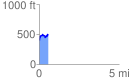
 0.567499 mi
 166.51 ft
 75.53 ft
 90.98 ft
 5.56 %
GPX Downloads: Track Route
![]()
| at: |
Homochitto National Forest |
show on map
animate
0.567499 mi
166.51 ft
75.53 ft
90.98 ft
5.56 %