| at: |
Homochitto National Forest |
Data from USFS GIS
 show on map
 animate
Trail users:


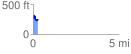
Elevation Profile
 0.272771 mi
 102.24 ft
 103.27 ft
 -1.03 ft
 7.17 %
GPX Downloads: Track Route
![]()
| at: |
Homochitto National Forest |
show on map
animate
0.272771 mi
102.24 ft
103.27 ft
-1.03 ft
7.17 %