| at: |
Homochitto National Forest |
Data from USFS GIS
 show on map
 animate
Trail users:


Elevation Profile
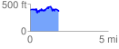
 1.851315 mi
 339.93 ft
 388.57 ft
 -48.64 ft
 3.98 %
GPX Downloads: Track Route
![]()
| at: |
Homochitto National Forest |
show on map
animate
1.851315 mi
339.93 ft
388.57 ft
-48.64 ft
3.98 %