| at: |
Homochitto National Forest |
Data from USFS GIS
 show on map
 animate
Trail users:


Elevation Profile
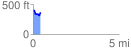
 0.431211 mi
 71.50 ft
 116.47 ft
 -44.98 ft
 5.12 %
GPX Downloads: Track Route
![]()
| at: |
Homochitto National Forest |
show on map
animate
0.431211 mi
71.50 ft
116.47 ft
-44.98 ft
5.12 %