| at: |
Homochitto National Forest |
Data from USFS GIS
 show on map
 animate
Trail users:


Elevation Profile
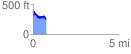
 0.754541 mi
 165.80 ft
 216.42 ft
 -50.62 ft
 5.43 %
GPX Downloads: Track Route
![]()
| at: |
Homochitto National Forest |
show on map
animate
0.754541 mi
165.80 ft
216.42 ft
-50.62 ft
5.43 %