| at: |
Homochitto National Forest |
Data from USFS GIS
 show on map
 animate
Trail users:


Elevation Profile
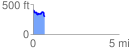
 0.659725 mi
 97.09 ft
 187.64 ft
 -90.55 ft
 5.39 %
GPX Downloads: Track Route
![]()
| at: |
Homochitto National Forest |
show on map
animate
0.659725 mi
97.09 ft
187.64 ft
-90.55 ft
5.39 %