| at: |
Homochitto National Forest |
Data from USFS GIS
 show on map
 animate
Trail users:


Elevation Profile
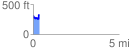
 0.380005 mi
 118.82 ft
 89.13 ft
 29.68 ft
 5.92 %
GPX Downloads: Track Route
![]()
| at: |
Homochitto National Forest |
show on map
animate
0.380005 mi
118.82 ft
89.13 ft
29.68 ft
5.92 %