| at: |
Homochitto National Forest |
Data from USFS GIS
 show on map
 animate
Trail users:


Elevation Profile
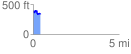
 0.427445 mi
 69.51 ft
 104.72 ft
 -35.21 ft
 4.64 %
GPX Downloads: Track Route
![]()
| at: |
Homochitto National Forest |
show on map
animate
0.427445 mi
69.51 ft
104.72 ft
-35.21 ft
4.64 %