| at: |
Homochitto National Forest |
Data from USFS GIS
 show on map
 animate
Trail users:


Elevation Profile
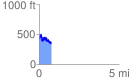
 0.765805 mi
 244.93 ft
 287.69 ft
 -42.76 ft
 7.11 %
GPX Downloads: Track Route
![]()
| at: |
Homochitto National Forest |
show on map
animate
0.765805 mi
244.93 ft
287.69 ft
-42.76 ft
7.11 %