| at: |
Homochitto National Forest |
Data from USFS GIS
 show on map
 animate
Trail users:


Elevation Profile
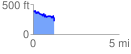
 1.240493 mi
 161.94 ft
 344.50 ft
 -182.56 ft
 5.26 %
GPX Downloads: Track Route
![]()
| at: |
Homochitto National Forest |
show on map
animate
1.240493 mi
161.94 ft
344.50 ft
-182.56 ft
5.26 %